I’m not saying I’m any better at route-finding than Val or
Penn. I just enjoy doing it, and take a certain pride when it works out, say
when I lead the lads through quiet, winding residential streets or down some
sleepy back alley. (The more serpentine and wiggling the route, the better, I
say.) And if I can work in a traverse of a grassy field or gravel path or
perhaps a full-on portage over a stream or barbed wire fence, so much the
better.
Conversely, I feel a small share of shame when a new route doesn’t
quite work out the way I’d hoped, when the traffic is heavier than I thought it
would be or the views disappoint. The fellows humour me, for the most part;
they accede to my cartographic whims and rarely say anything critical about my
work. But there is a certain responsibility borne by the cartographer. I have
to admit I have lain awake at night thinking of cycling routes. Cartographers
have reputations to uphold.
I’ll never understand why so many riders opt for boring,
traffic-laden routes when they just don’t have to. Like F.W Bockett, I shake my
head at cyclists who insist on grinding along busy main roads. Bockett preferred
“byways and lanes.” As he observed in 1901, “It is in the shady depths of these
narrow winding ways that the real delight and romance of cycling commences.”
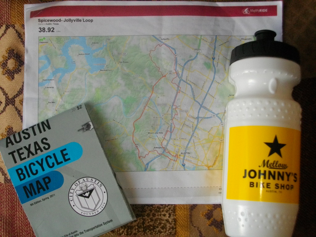
My last day in Austin, Texas, this past week, I rented a
good road bike from Mellow Johnny’s (Lance Armstrong’s store) and put my fate
in the hands of an unknown cartographer. The rental counter dude handed me a
sheet (actually four sheets, stapled together) with maps and cues, a mapmyride
called Spicewood-Jollyville Loop, 38.9 miles. At first, the cues looked
overwhelming; there had to be 70 turns in this route. Since I knew little of
Austin, I’d be constantly checking the damn sheet. Would I even see anything?
Despite my reservations, I decided that I had best trust the cartographer.
A few days previous I had gone out exploring with just a map
(a City of Austin cycling map, no less), thinking that with my cartographic
skills I could eschew a formal cue sheet and just figure out a pleasant route.
Big mistake. Things started out just fine, but only when I couldn’t find some
of my turns did I realize my map was from 2005. Things had changed in West
Austin since then. I ended up on some ugly and dangerous roads before
eventually finding my way back onto a recognizable bike route.
This time, though, I had a local cartographer on my side.
And within the first 5 miles, I realized I was in the hands of a master. The
route was ingenious, linking bike-laned road to bike-laned road, twisting
through residential neighbourhoods, avoiding lights and stops so elegantly.
Even the stretch along the major highway (which I had been highly skeptical of)
turned out to be surprisingly pleasant, with a huge shoulder and spectacular views
of the West Lake Hills.
Plus, unlike my experience in south-west Austin the
week before, here there was no garbage, no roadkill, even. It was as if the
cartographer had seen to it that this route was kept pristine. The cues were
obvious too; following the route was effortless. This cartographer was a veritable Yoda of the roada. So powerful was his or her magic, I barely had to
think about where I was going—some kind of force guided me along.
Just when I started thinking that I could use a coffee,
there appeared up ahead, as if in a mirage, a Krispy Kreme. Then the final stretch,
the finale: a dazzling, zig-zaggy ride back into the heart of downtown, ending
up on the Lance Armstrong Bikeway along the Town Lake. Masterful! At that
point, I wouldn’t have been surprised if the cartographer had arranged for
Lance himself to be waiting to shake my hand.
I don’t know who my Lone Star cartographer was but I do know
that routes like this don’t get created without hard work, passion, and a little
art. I know now just how brightly shines the work of a truly fine route-maker, and I feel humbled in my own meagre efforts at mapping out a loop. I tip
my cap to you, good sir or madam, and say thank you to all the cartographers
out there who help bring out the delight and romance of a good ride.
No comments:
Post a Comment
Speak up!